Everyone should ride Montana’s Going-to-the-Sun Road at least once. And then ride the surrounding roads forever more
It’s one of those famous roads people like to name-drop: “Going-to-the-Sun Road.” It’s right up there with “Beartooth Pass” and “Million Dollar Highway.” And with good reason. Montana’s Going-to-the-Sun Road has been titillating road travellers since 1932, bravely winding its way west, up the steep, narrow waist of the Rocky Mountains known as the Crown of the Continent, tipping over Logan Pass at the Continental Divide, then tumbling swiftly down the east side in undulating drops that eventually level into short-grass prairie.
It’s a world-class road, right up there with the famous passes in the European Alps, and if it weren’t for Going-to-the-Sun’s smothering crowds and snail-slow National Park speed limit of 25 mph, it would be just as fun to ride, too. Still, everyone should experience the scenic extravaganza at least once, taking time to marvel at the accomplishment. Imagine the sweat and peril involved in constructing such an ambitious road using equipment available in the 1920s. It took more than 10 years. Heck, it still takes 10 weeks to plow the top of the road each spring, and that’s using modern equipment that can move 4,000 tons of snow per hour.
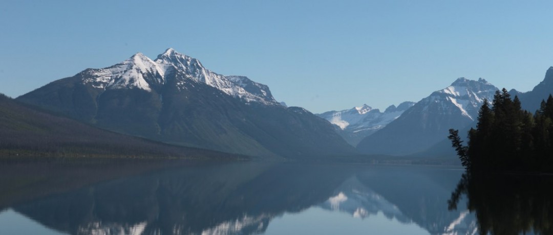
In fact, it was this last season’s delayed opening and record near-30 metres of snow on Logan Pass that stopped me in my tracks. I’d entered Montana’s Glacier National Park from the Columbia Falls side at first light, anticipating an empty road up Going-to-the-Sun Mountain, but alas, the valley was already swarming with amateur photogs bending out of car windows and anglers practically elbow to elbow on the edges of Lake McDonald. Somehow I’d miss the memo regarding the prolonged closure, a circumstance that left the throngs of tourists sequestered in the valley.
And so I retreated back into town, depressed that the much-anticipated zenith of my Montana travel was suddenly quashed. It was too early to drop into Packers Roost, Columbia Falls’ popular biker pub, to commiserate with the brethren, so I slumped down in a booth at the Huckleberry Patch Cannery and fed my disappointment a huge slice of homemade huckleberry pie, a local specialty.
Mad About Maps

Now U.S. 2 I’ve ridden before, all the way from Washington state to Michigan, and it’s a fantastic alternative to American interstate travel (though it doesn’t hold a candle to the Trans-Canada Highway in British Columbia for scenery and small-town flavour). From the west gate of Glacier Park, Hwy 2 keeps step with the fast-moving Middle Fork of the Flathead River, and thanks to the generous speed limits outside the park, I could follow just as rapidly. This is great riding, with smooth, long sweepers and little traffic. Just a few corners in, I was over my disappointment and beginning to realize Mother Nature had thrown me a bone.
On this stretch of U.S. 2, you’ll cross Marias Pass, which offers superb views of the east side of Glacier Park. It’s the lowest pass over the Continental Divide, at 1,589 metres, and has been the route of the Great Northern Railway and its successor, BNSF, since 1889. Railway buffs still gather at Marias Pass to watch the heavy freight trains crest the oft-snowy summit.
By the time I reached Essex, I was thoroughly invigorated and not missing anything about the snail’s pace of the park. I’d first ridden Going-to-the-Sun Road and Montana’s Rockies in 1990 on a Kawasaki ZX11 test bike back when it was the fastest production bike ever built. At the time, the state’s highway system was known as “America’s Autobahn,” legendary for having no posted daytime speed limits. The ZX11 was of course a terrible influence, and it didn’t take long to learn that the “reasonable and prudent” speeds permissible did not include triple digits.
Today’s speed limits are still some of the highest in the country, though the scenery in northwestern Montana begs for moderate speeds. By the time I turned north on Hwy 49, I was happy to snick my BMW K1600GT into a restful gear and revel in the unspoiled landscape.
A Land Without Borders

If you’re travelling east on Hwy 2, your GPS might recommend you travel to Saint Mary and the eastern terminus of Going-to-the-Sun Road via Browning, where U.S. 2 converges with U.S. 89. Don’t do it. Head north instead on 49 in East Glacier Park Village and get ready for some gorgeous views. Highway 49, which is closed in winter, climbs and twists through aspen groves and beautiful meadows, offering some of the best views of the glaciers in the distance. When you arrive at Two Medicine Lake, take the park road to the Two Medicine Campground (within the park) for a 28 km out-and-back that’s bursting with big views.
The breathtaking Hwy 49 ends at U.S. 89, also known as the National Parks Highway, since it strings together six of North America’s most beautiful National Parks along its 3,200 km north-south course. This particular section of U.S. 89 between Kiowa and Saint Mary is exceptionally beautiful, with awe-inspiring views of the sentinel-like Rockies, the exact scene that must have blown the minds of the early pioneers approaching the Great Divide from the east 200 years ago.
Today I’m very happy to have 160 horses to rush me up and into the Rockies. The K1600GT’s surreally smooth six purred sweetly as I untangled Hwy 89, growing ever closer to the backside of Going-to-the-Sun Mountain and its namesake road, which slumbered out of reach, deep beneath heavy snow.
Out of the Know

After some exploration into the Many Glacier area to the north, I finally turned west in Saint Mary on Going-to-the-Sun Road. This less-travelled section of the famous highway sweeps gracefully around the shores of Saint Mary Lake as it slowly rises toward Logan Pass. As the peaks draw nearer, the colour that from a distance looks grey shifts to distinct tints of burgundy, light green, red and tan. The true glacier that carved and coloured this park melted 12,000 years ago. The glaciers that exist here today are new, and tiny by comparison.
Twenty-four kilometres in, I’m stopped once again, this time just 13 km short of Logan Pass and the most famous stretch of Going-to-the-Sun Road. But I’m not sad. Perhaps on a perfect day, Going-to-the-Sun would be open and I’d close the loop with a sloth’s-pace ride through the park, but today I’m just grateful. I’ve had an utterly fantastic afternoon of riding. I’ve enjoyed countless empty corners and heart-goosing views. I’ve seen mountain goats, a grizzly bear, a moose, a wolverine and very few people.
And by the time I turn in tonight, I’ll have bookended my day with a second slice of delicious homemade huckleberry pie. This time with ice cream. Because just outside Glacier National Park, you can always have your pie, and eat it a second time, too.


