One of British Columbia’s greatest day rides
Depending on which way you decide to travel the Duffey Loop, it is one of the most loved and known rides on British Columbia’s Lower Mainland and almost all riders have travelled on it or are planning to ride it some day. My usual count is three times a season; often, my first of the year is just to see how early in the year I can make a full loop.
My preferred direction to ride it in is clockwise; others like doing it counter-clockwise. I’ve done it both ways, but for this article, we’ll go clockwise to make it easy to follow.
Leaving Vancouver, you have the choice of taking either the Lions Gate Bridge from downtown or, if coming in from East Van or Burnaby, the usual choice is the Ironworkers Memorial Bridge. Both these routes take you to the Upper Levels Highway and the Trans Canada Hwy. 1 out to Horseshoe Bay. Here, the highway becomes Highway 99, a.k.a. the Sea to Sky Highway.
A Nice Scenic Road

There are ample passing lanes as you wind along the coastline, so no need to get frustrated if you get stuck behind slower vehicles. Just slow down and take in the scenery. The first bedroom community you will pass through is Lions Bay. The speed limit here is 60 km/h and a favourite place for cops to set up. It’s very twisty through here, and they can hide around any number of corners.
Leaving Lions Bay, you come to Porteau Cove, a nice public park with a boat launch and campground (which is almost always full) and some good straight stretches ahead at Furry Creek, known for its beautiful golf club, part of which can be seen from the road.
The next small place you ride through is Britannia Beach, an old mining town that still offers mine tours and has an interesting museum. It’s worth a stop if you’ve never been there or have a hankering to go underground.
More Speed Traps

On that note, on weekends in the summer, there may be 100 to 300 motorcycles on this road, so keep your eyes on your mirrors – the sport bike guys come up really fast and often ride in groups. They can and will surprise you if you’re daydreaming.
The next town you come to is Squamish, a larger suburb of Vancouver with shopping. The Starbucks at the mall off Cleveland Avenue is a stop frequented by bike riders. Affectionately known as Squambucks, it always has at least 30 bikes parked here, with riders in the process of coming or going during the weekend in summer months.
Continuing north on Hwy 99 from Squamish, you will pass by the turnoff to Brackendale, known for having the largest concentration of bald eagles in North America from November to February.
Keep Moving On
From here, the road gains in elevation as it winds through mountain terrain. You will be able to keep a good speed right into Whistler, where things slow down again. Not much to see here in summer unless you’re into tourist traps and expensive shopping. Don’t get me wrong: it’s a nice sterile town and you can take a gondola ride or go downhill mountain biking and there’s great skiing in the winter. But this is a motorcycle-related article.
There is a Chevron gas station in Whistler that offers 94-octane gas for those needing it. Chevron is the only gas station in B.C. to offer 94 octane that is ethanol-free, and you will pay a premium for it. I paid as high as $1.78 per litre in 2018.
Once you leave Whistler, you’ll notice that the road isn’t as wide or as well cared for as it was behind you. Still, it’s a fine ride into Pemberton, which is the usual gas stop for most riders as there are both a Petro Canada and a Husky station in town. Worth mentioning: Pemberton has a real shortage of restaurants, so if your planning to find a nice place to eat, there’s only two or three places to choose from, plus a McDonalds and, of course, fine gas-station dining.
Leaving Pemberton, you pass Mount Currie as you ride through the Lil’wat First Nations reserve. Please respect the posted speed limits here: it’s 30 km/h, but only for a short distance. Soon you’ll make a right turn to follow Hwy. 99, a.k.a. Lillooet Lake Road, which turns into Duffey Lake Road.
Lose the Traffic

The first large lake you pass on your left is Duffey Lake. From here, the road is very winding with lots of switchbacks. Watch for gravel in the corners from people pulling trailers who don’t watch their off-track, so their trailer wheels hit the shoulders and drag gravel onto the road. Many good riders have gone down on this stretch of road due to gravel.
You’ll notice that there are as many crossings of Cayoosh Creek as there are switchbacks on your way up toward Cayoosh Summit, where the mountain views continue.
Coming into Lillooet is a winding and narrow road along the side of the mountain with steep drop-offs and very rugged terrain. Hopefully, you filled up in Pemberton because getting stuck out here is not something you want to do.
Lillooet is a must stop for fuel, with most people filling up at Lightfoot Gas, another Chevron that offers 94 octane gas. Coming into Lillooet, you’ll notice that the temps rise and the landscape becomes very arid – almost desertlike in places – compared with what you’ve been riding through to this point.
A Change of Route?
Here you have a choice to make: you can do the original Duffey Loop by continuing on through Fountain Valley, Marble Canyon and on toward Cache Creek or you can turn south on Hwy. 12 and do the shorter version of the loop to Lytton. The difference is 581 km, as the full Duffey Loop is a 691-km ride.
For the sake of our ride, we’ll stick to the original loop and continue on to Fountain Valley, a small First Nations community that straddles a short bit of road through the Fountain Slide, a hillside that never stops moving. The road is a short dirt section that always has a flag person stationed there because of construction. After that stretch, you’re back on pavement heading toward Pavilion, Marble Canyon and the historic Hat Creek Ranch, where Hwy. 99 ends and meets Hwy. 97. A right turn takes you onto the Cariboo Highway and into Cache Creek.
Cache Creek is another gas stop, with a Chevron offering 94 octane.
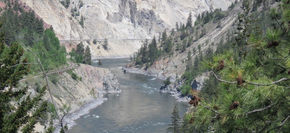
South of Cache Creek, you find yourself back on the Hwy. 1 and heading toward the Fraser Canyon, which takes you all the way back to Hope. You’ll ride across Spences Bridge, which spans theThompson River, and follow along the side of the canyon all the way into Lytton. Remember Lytton? This is where the riders who took the shorter loop return to Hwy. 1.
Lytton is also where the Thompson River meets the Fraser River. If you stop at the bridge in Lytton, you can see where the clear waters of the Thompson run into the very muddy Fraser River – an interesting sight, for sure.
Travelling south in the canyon, you pass by Kanaka Bar, North Bend, Boston Bar, the climb over Jackass Mountain to Hell’s Gate, cross over the Fraser River and toward Alexandra Provincial Park. You will pass through a number of tunnels that take you through to Spuzzum, Saddle Rock, Yale and Hope, the last of which is a must stop for gas with two Chevron gas stations to choose from.
Wrapping up the Ride
Two good places to eat in Hope are Home Restaurant or Rolly’s Restaurant.
Rolly’s is right behind the Chevron on Water Avenue, which is the road you just rode in on. Home Restaurant is about a three-minute ride on Old Hope Princeton Way on the road out of town heading east. Both restaurants are equally good and can be busy, but the wait is worth it and you can chat with other riders that are sure to be there about the awesome bit of road you’ve just ridden.
From Hope back to Vancouver, you have two options: Hwy. 1 (a.k.a. the “slab”) or take the scenic Hwy. 7 through Agassiz, Harrison Mills, Lake Errock and Deroche (where you can buy fireworks year-round), then on through Dewdney, Hatzic and into Mission. This stretch of road is a nice two-lane ride through farmland and mountain views.
At Mission, you have the option of taking Hwy. 11 down to Abbotsford and join up with Hwy. 1 to save time or pick your way through Maple Ridge, as many riders do.
No matter how you ride the Duffey Loop, it will leave a lasting impression on you. Without a doubt, the loop is one of B.C.’s great rides.


